Along the Greenway: Development and Redevelopment in Downtown Boston
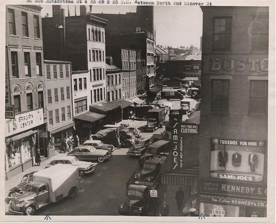
Blackstone Street near Government Center, as seen from Hanover Street.
The photograph above faces buildings that once stood along Blackstone Street, very near today’s Greenway. Where did these buildings go? What prompted the area to change so dramatically, from a center of commerce made up primarily of low brick and stone structures to a linear urban park and a series of high-rise office and government buildings?
Find out on my tour along Boston's Greenway. Pass through the footprint of the original city of Boston and discover how downtown Boston originally developed. As we pass through the streets—some original, others later realignments—see firsthand the dramatic extent to which Boston’s centers and squares have changed over time. Along the way, see how the development of transit trends shaped and reshaped the city of Boston and appreciate transit-oriented development, not a new phenomenon by any means, in a new way.
The tour begins by 99 High Street, a three-minute walk from South Station on the MBTA's Red Line. The tour ends at the corner of Haverhill and Causeway Streets in the West End, just by North Station on the MBTA's Green and Orange Lines. The tour lasts 90-120 minutes.
