Any questions? Feel free to shoot an email:
Boston Streetcars
  • Home
  • Media
    • About Streetcar Tracks
    • Script
    • Press
    • About The Author
    • Research Process
  • About the T
    • Mattapan High-Speed Line
    • Green Line >
      • Subway
      • B Branch
      • C Branch
      • D Branch
      • E Branch >
        • What Happened to the Arborway Line?
      • What Happened to the A Line?
    • Trackless Trolleys
    • Orange Line
    • Red Line
    • Blue Line
    • Photographing the T
  • Articles
    • Why Are There Still Streetcars in Boston?
    • Boston's Cancelled Highways
    • The West End's Transformation
    • How A Streetcar Works
    • "Streetcar Suburbs" of Boston >
      • Triple Deckers of Boston
      • Dorchester's Blue Hill Avenue
      • Dorchester's Jones Hill: How the Hill Developed
    • Trolley Remnants
    • Transit Hubs of Boston >
      • Sullivan Square
      • Dudley Square
      • Massachusetts Station
      • Egleston Square
      • Copley Square
      • Grand Junction Railroad
    • Trolley Types of Boston
    • The Growth of Boston Rapid Transit
    • Five Key Future Boston Transit Investments
    • Streamlining Boston Transit to Olympic Specifications >
      • Comments on South Boston Transit Study
    • Last Time Over the Casey Overpass
  • Tours
    • About
    • FAQ
    • Descriptions of Tours >
      • Changes in Boston's West End
      • The Evolution of Commonwealth Avenue
      • Changes Around Copley Square and Northeastern University
      • Urban Development Along the Freedom Trail
      • "Streetcar Suburbs" of Boston: Dorchester's Ashmont
      • Along the Greenway
      • Development of Dudley
      • Working Waterfront
      • Fort Point
    • Reviews

Development of Dudley: The Evolution of Fort Hill, Dudley Square and Lower Roxbury

Picture
Picture
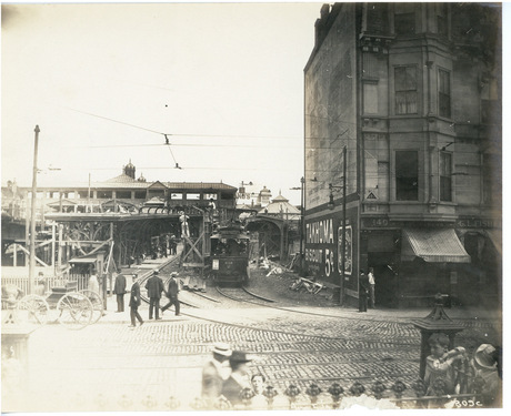
Roxbury's Dudley Square in 1910.
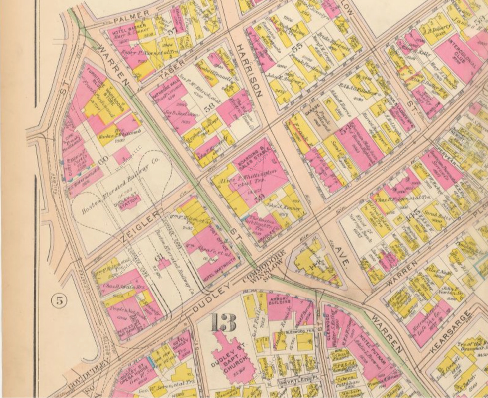
1915 Bromley map of Dudley Square.
The Dudley Square area's residential, commercial and transportation infrastructure has experienced several phases of development and redevelopment. This foot tour will focus upon the process of the Dudley Square area's urban development. Beginning by Northeastern University and ending in Roxbury Crossing, the tour will show the evolution of Dudley Square and the surrounding area through remnants of the various stages of the area's transit network and commercial/residential development.

Logistics and Signup/RSVP:

The tour will be held on Thursday, January 1st, 2015 (New Year's Day) at 12 PM Noon. The tour will begin by the Forsyth Street entrance to Ruggles Station on the MBTA Orange Line, on the Northeastern University campus and a two minute walk from Northeastern University Station on the MBTA Green Line. The tour will end at Roxbury Crossing Station on the MBTA Orange Line and Bus Routes 19, 22, 29 and 66; Roxbury Crossing is also a 10 minute walk from Brigham Circle Station on the MBTA Green Line.


The tour will last 90-120 minutes. Rates are as follows: $20 for Adults 18+, $10 for Children 13-17, Children 12 and under free. Group rates available upon request.

    RSVP for Development of Dudley—12PM on 1/1/2015 (New Year's)

    -
    -
Submit
Tour Starting Point:
Tour Ending Point:
Powered by Create your own unique website with customizable templates.