Any questions? Feel free to shoot an email:
Boston Streetcars
  • Home
  • Media
    • About Streetcar Tracks
    • Script
    • Press
    • About The Author
    • Research Process
  • About the T
    • Mattapan High-Speed Line
    • Green Line >
      • Subway
      • B Branch
      • C Branch
      • D Branch
      • E Branch >
        • What Happened to the Arborway Line?
      • What Happened to the A Line?
    • Trackless Trolleys
    • Orange Line
    • Red Line
    • Blue Line
    • Photographing the T
  • Articles
    • Why Are There Still Streetcars in Boston?
    • Boston's Cancelled Highways
    • The West End's Transformation
    • How A Streetcar Works
    • "Streetcar Suburbs" of Boston >
      • Triple Deckers of Boston
      • Dorchester's Blue Hill Avenue
      • Dorchester's Jones Hill: How the Hill Developed
    • Trolley Remnants
    • Transit Hubs of Boston >
      • Sullivan Square
      • Dudley Square
      • Massachusetts Station
      • Egleston Square
      • Copley Square
      • Grand Junction Railroad
    • Trolley Types of Boston
    • The Growth of Boston Rapid Transit
    • Five Key Future Boston Transit Investments
    • Streamlining Boston Transit to Olympic Specifications >
      • Comments on South Boston Transit Study
    • Last Time Over the Casey Overpass
  • Tours
    • About
    • FAQ
    • Descriptions of Tours >
      • Changes in Boston's West End
      • The Evolution of Commonwealth Avenue
      • Changes Around Copley Square and Northeastern University
      • Urban Development Along the Freedom Trail
      • "Streetcar Suburbs" of Boston: Dorchester's Ashmont
      • Along the Greenway
      • Development of Dudley
      • Working Waterfront
      • Fort Point
    • Reviews

The Evolution of Commonwealth Avenue

Picture
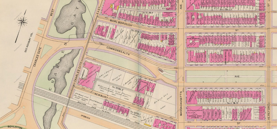
1898 Bromley map of Commonwealth Avenue and Charlesgate Park in Boston's Back Bay.
A foot tour that shows how Commonwealth Avenue in Allston, Kenmore Square and the Back Bay has evolved over time, from a bare strip of landfill to today's well-planned boulevard home to Kenmore Square, Boston University and other Boston landmarks. Come on this foot tour and hear and see for yourself how Commonwealth Avenue was shaped and reshaped by the filling in of land, construction of trolleys, urban renewal and more. Also experience the evolution of the resources the Avenue has hosted and the function the Avenue has served in Boston's infrastructure. Through the relatively abundant, though easily missed, remnants of Commonwealth Avenue's past, you will come to appreciate the rich history of one of Boston's busiest boulevards.
Powered by Create your own unique website with customizable templates.