Working Waterfront:
Changing Industries in Downtown and Fort Point
Changing Industries in Downtown and Fort Point
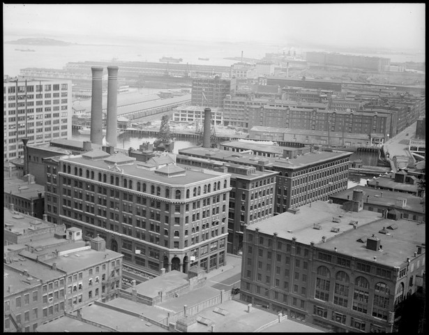
1929: Congress Street and Atlantic Avenue, looking towards Fan Pier and Fort Point.
The 1929 photograph above faces Russia Wharf, site of today’s Atlantic Wharf waterfront development. Across Fort Point Channel is South Boston’s Fort Point neighborhood, as well as the former rail yards of Fan Pier. Today, the waterfront and Fort Point Channel are lined with many office towers, as well a number of hotels and a growing residential presence. However, the older buildings’ meticulously detailed facades and the Channel’s carefully crafted riveted bridges speak of a rich industrial heritage dating back years.
On my Working Waterfront tour, we’ll talk about the variety of roles Boston’s waterfront has played dating back to Boston’s original settlement. As we walk along the narrow alleys and wider arteries of downtown and Fort Point, we’ll examine remnants of the area’s various stages of commercial, industrial and residential development and discuss what factors prompted the area to change over time. With the help of historic maps and photographs, we’ll relive downtown’s past and gain insight into the extent to which the area has changed. Along the way, we’ll note the former paths of since-removed downtown public transit infrastructure. We'll also stop by the sites of planned, under construction and recently completed real estate projects that are ushering in a new era of Boston waterfront development.
We will meet at South Boston’s locally brewed Barrington Coffee, located at the FP3 development (346 Congress Street) in Fort Point. Two dates are offered: Tuesday, July 7th, 2015 and Thursday, July 9th, 2015; both tours will begin at 6PM. The tour will last approximately 90 minutes and end just by Faneuil Hall, across from Christopher Columbus Park and the Aquarium MBTA station.
Stops include:
Price: $20.00. Buy tickets below or on the Eventbrite page, https://eventbrite.com/event/17558841969/.
On my Working Waterfront tour, we’ll talk about the variety of roles Boston’s waterfront has played dating back to Boston’s original settlement. As we walk along the narrow alleys and wider arteries of downtown and Fort Point, we’ll examine remnants of the area’s various stages of commercial, industrial and residential development and discuss what factors prompted the area to change over time. With the help of historic maps and photographs, we’ll relive downtown’s past and gain insight into the extent to which the area has changed. Along the way, we’ll note the former paths of since-removed downtown public transit infrastructure. We'll also stop by the sites of planned, under construction and recently completed real estate projects that are ushering in a new era of Boston waterfront development.
We will meet at South Boston’s locally brewed Barrington Coffee, located at the FP3 development (346 Congress Street) in Fort Point. Two dates are offered: Tuesday, July 7th, 2015 and Thursday, July 9th, 2015; both tours will begin at 6PM. The tour will last approximately 90 minutes and end just by Faneuil Hall, across from Christopher Columbus Park and the Aquarium MBTA station.
Stops include:
- South Station
- Fort Hill Square
- Wendell Street
- Rowes Wharf
Price: $20.00. Buy tickets below or on the Eventbrite page, https://eventbrite.com/event/17558841969/.
