What Happened to the A Line?
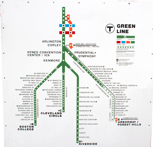
Typical Green Line map that shows the Arborway Line as "temporarily suspended." Image taken from the MBTA's gifts website.
Something is odd about the map above. Why is the first branch of the Green Line called the B Line when A is the first letter of the alphabet? Wouldn't it make sense to start at the beginning rather than one letter in?
It sure would make sense that way, and for a short period in the MBTA's history the Green Line was actually organized that way. When the MBTA took over Boston's transit system from the MTA in 1964, six streetcar lines remained. One was the Mattapan Line, four were today's Green Line branches and one was a streetcar that went through Brighton all the way to Watertown. When the MBTA assigned colors to its different lines in 1967, that one streetcar became the A branch of the Green Line:
It sure would make sense that way, and for a short period in the MBTA's history the Green Line was actually organized that way. When the MBTA took over Boston's transit system from the MTA in 1964, six streetcar lines remained. One was the Mattapan Line, four were today's Green Line branches and one was a streetcar that went through Brighton all the way to Watertown. When the MBTA assigned colors to its different lines in 1967, that one streetcar became the A branch of the Green Line:
The A Line ran through Boston University along the same right-of way that the B Line used then and still uses today. When the lines reached Packards Corner, the A Line would diverge from the B Line and continue down Brighton Avenue towards Watertown. One can still see a stub of the old A Line switch at Packard's Corner today, not to mention a good amount of A Line trackage remaining at Watertown Yard, the former A Line terminus that is now a bus yard: (Photos will be uploaded soon)
Today, the A Line's route is serviced by the 57 bus, with runs from Watertown to Kenmore requiring a transfer to get to downtown Boston. Why would the MBTA replace the A Line with a bus? The answer, just like for many other streetcar lines that were eliminated, is that the A Line ran in the street. From Packards Corner to Watertown, the A Line ran in the street along with cars, and when the streetcar stopped the cars had to stop too. And that wasn't all—if you've ever driven in Newton Corner over the Mass Pike, you have probably experienced the terrible congestion that sometimes occurs in the area. Guess what? The A Line ran over that ramp.
When the Pike was completed in 1964, the same year the MBTA was founded, the A Line continued to be routed through Newton Corner as it had always been, but now the ramp was one-way. How did officials solve the problem? By putting in a contraflow, street-running lane for the A Line to cross the ramp in the opposite direction from traffic! As though getting a streetcar across that overpass wasn't a hard enough challenge. As you can imagine, the contraflow lane caused quite a bit of confusion for motorists. Officials originally thought that the contraflow lane wouldn't be an issue because the exit in Newton would not be used very heavily, but they were wrong and the exit quickly became very busy, as it still is today:
When the Pike was completed in 1964, the same year the MBTA was founded, the A Line continued to be routed through Newton Corner as it had always been, but now the ramp was one-way. How did officials solve the problem? By putting in a contraflow, street-running lane for the A Line to cross the ramp in the opposite direction from traffic! As though getting a streetcar across that overpass wasn't a hard enough challenge. As you can imagine, the contraflow lane caused quite a bit of confusion for motorists. Officials originally thought that the contraflow lane wouldn't be an issue because the exit in Newton would not be used very heavily, but they were wrong and the exit quickly became very busy, as it still is today:
Imagine getting a streetcar through there. And that isn't the messiest that intersection gets—it is a wonder the streetcar ever made it through during rush hour!
With the new 504 bus running from Watertown Yard along the new Pike to downtown, cutting travel time from Watertown to downtown significantly, and the danger the contraflow lane caused, it no longer made much sense to continue running the A Line as a streetcar. Therefore, to make things easier, the MBTA ended service on the A Line in 1969 and replaced the A Line with the 57 bus. The bus could be safely routed around the Pike ramp along with traffic, and riders along the A Line route in Brighton would not be left without public transportation. A loop in Oak Square halfway along the A Line route still existed as of 1961, but it made more sense to operate a bus along the whole route rather than just operate a streetcar halfway:
With the new 504 bus running from Watertown Yard along the new Pike to downtown, cutting travel time from Watertown to downtown significantly, and the danger the contraflow lane caused, it no longer made much sense to continue running the A Line as a streetcar. Therefore, to make things easier, the MBTA ended service on the A Line in 1969 and replaced the A Line with the 57 bus. The bus could be safely routed around the Pike ramp along with traffic, and riders along the A Line route in Brighton would not be left without public transportation. A loop in Oak Square halfway along the A Line route still existed as of 1961, but it made more sense to operate a bus along the whole route rather than just operate a streetcar halfway:
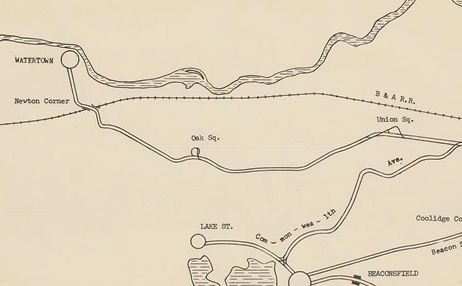
MTA Track Map from 1961, Map Courtesy of Ward Maps
The tracks of the A Line stayed in place to Watertown until the 1990s. The MBTA continued to use the tracks occasionally to bring streetcars to Watertown Yard for maintenance, but eventually those tracks were dismantled for road reconstruction.
